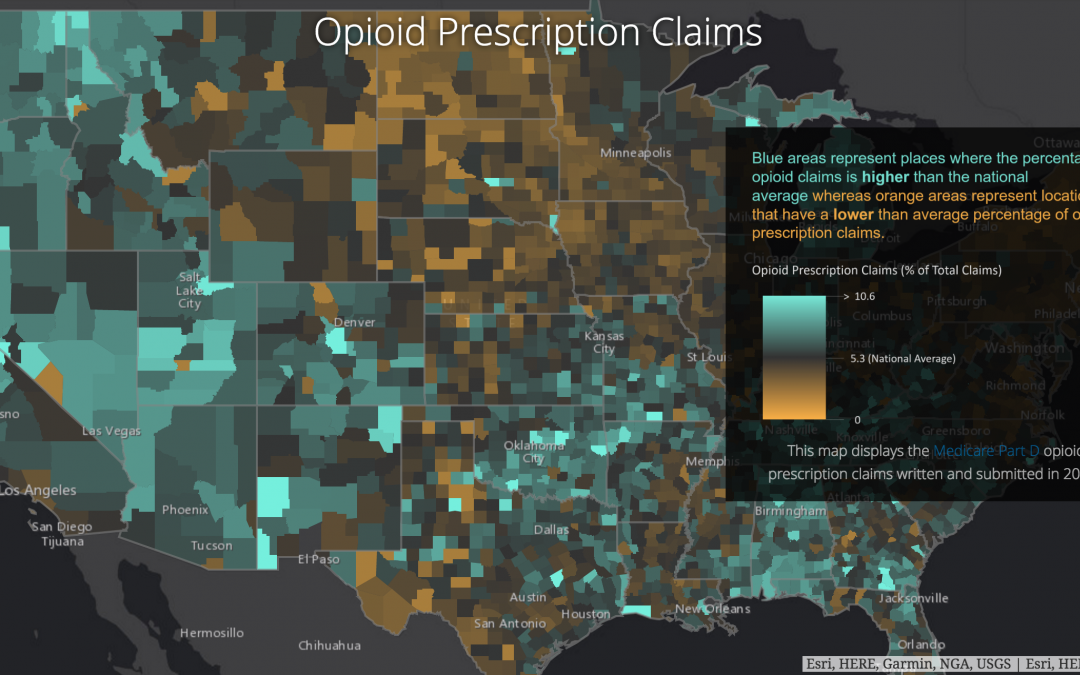
Route 50 talks about the importance of maps in telling the story of the opioid epidemic and how it can help public officials in particular drive home the point. Sometimes a picture is worth far more than 1,000 words. One of the challenges I see is the huge amount of data associated with prescription monitoring. We have to make it easy to assess for health care professionals (and, really, everyone) involved with the problem. Maps are one tool to do this. Route 50 mentions one Kentucky effort.
The Northern Kentucky story map does more than just put all of the health department’s publicly available data in one place, it also contains information about syringe exchange programs and treatment options in the region and lets people know where they can obtain life-saving naloxone kits. In short, the story map helps clearly communicate the extent of the problem, and all the government-led initiatives in place to combat it.
Putting out these maps has shown results.
The map has had a concrete impact on how this region tackles the epidemic. Since the map went live, for instance, Judge Moore credits the tool, at least partly, with facilitating one piece of pending legislation.
I think using maps to help a wider audience understand the scope of the problem is a great idea. We will see more change faster if we tell a compelling story, supported by images that make sense for visual thinkers. In PastRx, we use maps to make it easy to see how far a patient travels to fill their prescriptions. I’d love to hear about maps and other infographics you find effective in putting the word out. How you use maps in prescription monitoring?
David Stengle
Chief Marketing Officer
Thank you very much for sharing, I learned a lot from your article. Very cool. Thanks. nimabi
إن تركيبات uPVC التي ينتجها مصنع إيليت بايب Elite Pipe مقاومة للغاية للتآكل ، وتوفر حلولاً موثوقة وخالية من الصيانة لأنظمة الري والسباكة.
Usually I do not read article on blogs, however I would like to say that this write-up very compelled me to take a look at and do so! Your writing taste has been amazed me. Thanks, quite nice post.
I was recommended this website by my cousin. I am not sure whether this post is written by him as nobody else know such detailed about my difficulty. You are wonderful! Thanks!
Fantastic site Lots of helpful information here I am sending it to some friends ans additionally sharing in delicious And of course thanks for your effort
Can you be more specific about the content of your article? After reading it, I still have some doubts. Hope you can help me. https://accounts.binance.com/es/register?ref=T7KCZASX
Your article helped me a lot, is there any more related content? Thanks! https://accounts.binance.com/cs/register?ref=B4EPR6J0
hiI like your writing so much share we be in contact more approximately your article on AOL I need a specialist in this area to resolve my problem Maybe that is you Looking ahead to see you
The most common surgical finding is a single adenoma but encountering multiple parathyroid adenomas is more common in normocalcemic 12 than in hypercalcemic 4 hyperparathyroidism buy generic cialis
Your website is awesome! I’m genuinely enjoying the insightful content and the cool design—it feels like a user-friendly playground. Kudos for your dedication! Let’s chat and brainstorm some fantastic ideas.
Your point of view caught my eye and was very interesting. Thanks. I have a question for you. https://www.binance.info/it/join?ref=53551167
Simply desire to say your article is as surprising. The clearness in your post is simply excellent and i could assume you are an expert on this subject. Fine with your permission let me to grab your feed to keep up to date with forthcoming post. Thanks a million and please carry on the gratifying work.
Your article helped me a lot, is there any more related content? Thanks! https://www.binance.com/pl/register?ref=JHQQKNKN
Can you be more specific about the content of your article? After reading it, I still have some doubts. Hope you can help me. https://www.binance.info/pt-BR/join?ref=B4EPR6J0
Hi my loved one I wish to say that this post is amazing nice written and include approximately all vital infos Id like to peer more posts like this
В Карачаево-Черкесской республике, поселке Домбай, ул. Карачаевская, 72. Спортивно-оздоровительная база “Домбай” https://robocupdombay-otbor4.ru/.
What i do not realize is in fact how you are no longer actually much more wellfavored than you might be right now Youre very intelligent You recognize thus considerably in relation to this topic made me in my view believe it from numerous numerous angles Its like men and women are not fascinated until it is one thing to do with Lady gaga Your own stuffs excellent All the time handle it up
Thank you for your sharing. I am worried that I lack creative ideas. It is your article that makes me full of hope. Thank you. But, I have a question, can you help me? https://www.binance.com/ru/register?ref=FIHEGIZ8
Thank you for your sharing. I am worried that I lack creative ideas. It is your article that makes me full of hope. Thank you. But, I have a question, can you help me? https://www.binance.info/pl/join?ref=JHQQKNKN
Can you be more specific about the content of your article? After reading it, I still have some doubts. Hope you can help me.